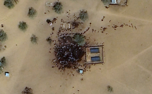
In early November 2025, popular social media creators and outlets began to shed light on the atrocities committed by the Sudanese paramilitary group Rapid Support Forces (RSF) in the southwest region of Sudan. Images in which “the massacres in Sudan could be seen from space” began circulating on the internet, as people saw a screenshot from Google Maps of a location in Kumia, East Darfur, Sudan.
The satellite image appears to show dozens of small dark objects, suggested by many online to be corpses, in an area with sand stained a blood-like color. The striking snapshot provoked many online to call for action in favor of the civilians of Sudan. A post on X captioned, “this is the most disturbing google earth image ever… SPEAK ON THE GENOCIDE OF SUDAN,” amassed over 15 million views before it was taken down by the author.
There is no manipulation in the satellite image. However, the date of the photo was March 16, 2024, making it irrelevant to any recent changes to the current state of the conflict. Moreover, the same location on Apple Maps shows objects more resembling farm animals than bodies.
From these factors, Benjamin Strick of the Centre for Information Resilience concluded that the image most likely shows livestock, probably cattle, surrounding a water well. Animals such as cattle, sheep, goats, and camels are very common in rural Sudan, as the country ranks first to third in the number of them out of all African countries. Sudanese water wells, known as Donki, frequently nurse livestock on hot days, and are often powered by solar panels, which are visible in the image.
Nonetheless, seeing one example online that might not suggest the killings doesn’t mean that the crimes are not being committed.
Skyline student Faiyad I. said he believes “in the Skyline community, we are [all] compassionate and want the truth, so if something wrong is going on in the world, we need to fight for change, but we need the truth.” He also said that the “source of information needs to be credible, even if they are established, in order to get the full truth.”
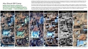
Satellite imagery from the major city of al-Fasher posted by Yale University’s Humanitarian Research Lab (HRL) accurately suggests the atrocities in the country are visible from space. “Yale HRL interprets that the activity visible in satellite imagery on 27 and 28 October reflected high-tempo killings and clearance of people in that neighborhood,” the Lab claims.
Strick believes that what’s “more unfortunate is that out of all things that were to come out of Sudan over the past two weeks, [the image of Kumia] had the most views. It means that people can say, maybe [the other footage of human rights abuses] is fake […] and it’s [actually] real.”
For more information:
Sudan: Escalating Conflict in Khartoum and Attacks on Civilians in al-Jazirah and South Kordofan
Livestock in the Republic of the Sudan: Policies, production, problems and possibilities
Arduous journeys to search for water in North Kordofan, Sudan
Severe Water Shortage Hits Rural West Kordofan
Satellite images reveal “mass killing is continuing” in Sudan, Yale researchers say